
LEVERAGING ADVANCED REMOTE SENSING TECHNOLOGIES TO PROTECT OUR COMMUNITIES AND NATURAL RESOURCES
Wildfires consume millions of acres of land every year, destroying homes, communities, and infrastructure across the United States and around the globe. Fire seasons are getting longer, and fires are increasing in intensity as droughts increase and the effects of climate change become more pronounced. The economic and environmental impacts are devastating and costly, necessitating a closer study of wildfire causes and risk mitigation to better assess and minimize risk and damage.
With recent advancements in remote sensing technology, LiDAR data collection, and fire science, more and more solutions are becoming widely available for fire tracking and containment. In fact, AEVEX Aerospace collaborates with several fire departments – including the Orange County Fire Authority (OFCA) – on fire programs that enhance intelligence, surveillance, and reconnaissance technology for wildfires throughout the United States. The program lead for OFCA currently operates a FLIR 380-HD and an Overwatch TK-9 sensor onboard a King Air 200 aircraft. This system transmits video, maps, and images of burning fires in real-time to fire fighter control and command centers. Real-time analysis puts accurate information in the hands of crews and fire management personnel. For more information about this technology, please click here.
Considering the cost of operating such systems from manned aircraft, Geodetics (an AEVEX Aerospace company) is working on a UAV prototype equipped with several tightly coupled onboard sensors, allowing for data acquisition and modeling techniques to measure relevant variables for wildfire management and risk assessment. This UAV prototype is ideal for targeted wildfire management in reasonably spotted areas, and offers much lower overhead costs when compared to manned aircraft missions. An assessment of susceptible areas could produce models that characterize wildfire likelihood, intensity, and impacts. Measurable variables including topography, vegetation health (moisture content), land cover types, and relative temperature can aid in predicting the severity and intensity of wildfires. The specialized Geo-MMS (Mobile Mapping System) payload used in this study includes a long-range LiDAR sensor, RGB, multispectral, and thermal imaging sensors. The figure below outlines the system prototype with integrated sensor performance:
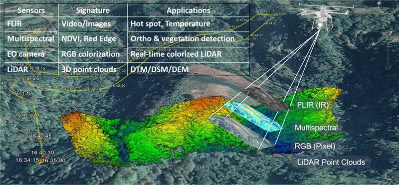
Figure 1. Overview of the sensors employed in Geodetics’ UAV-based wildfire management system.
Geodetics approach to wildfire risk assessment involves a hybrid drone that can remain airborne for several hours during data collection. The proposed payload includes the long-range Optech CL-360XR LiDAR sensor, A growing multispectral imaging sensor, Sony α7R II RGB camera, and FLIR longwave infrared thermal sensor. Note that these sensors can be customized to meet different project demands and requirements.
These onboard sensors together provide accurate and reliable data for a wildfire risk prediction model. LiDAR data provides high-resolution, fine-scale measurements that can extract biophysical features of vegetation as well as creation of DTM/DEMs. The sensor measures the structural data, giving accurate and reliable information about topography, slope, and vegetation characteristics: canopy height, crown length, tree basal area, density, diameter, and dead tree density.
Originally published by Geodetics


