
LiDAR Sensors for UAV / Drone Application
When selecting the right LiDAR you must consider the various parameters that define the performance of the LiDAR sensor. These parameters are summarized in the table below.
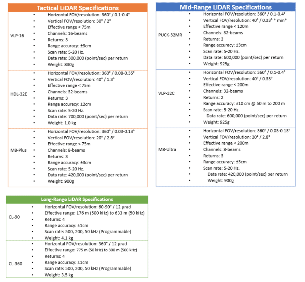
LiDAR Specifications Listed by Range
If you are an expert in LiDAR scanning, you can probably stop here. Otherwise, this article provides assistance in selecting the right LiDAR sensor for your application. There are several approaches to narrowing down the right LiDAR sensor. The first, and probably the easiest, is basing your decision on price. Another approach is based on considering factors such as operational environment, the weight of the sensor which impacts the flight duration, etc. There is nothing wrong with these approaches; however, here, we tackle this question from a different perspective. In our approach, we consider flight altitude, required resolution and the application. The reason we drop accuracy from consideration is that in most cases, regardless of the LiDAR sensor, the desire is the highest accuracy.
Flight Altitude
In LiDAR mapping, the flight altitude is a key parameter in picking the appropriate sensor. If you can fly below 60m AGL, the tactical-range sensors are appropriate. For altitudes higher than 60m, you must consider either mid-range or long-range LiDAR sensors as shown below.
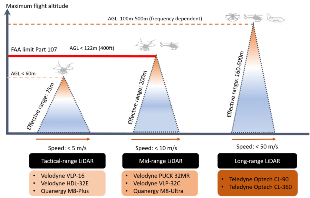
LiDAR-Sensor-Flight-Altitude-1024×655-1
Resolution
The projection of a single laser beam onto the ground yields its resolution. The resolution is a function of the flight altitude, scan rate (frequency) and the angular resolution. A minimum resolution for the tactical/mid-range LiDAR is about 5-10cm@30m; while for long-range LiDAR’s is about 2-3@100m. The frequency and angular resolution of the tactical-range and the mid-range LiDAR sensors are in the same range. Thus, if you need a similar or higher resolution at higher altitudes, then you must use a long-range LIDAR sensor.
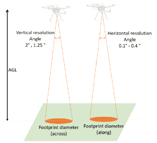
Resolution-and-Footprint-Size-1
Application
The last parameter to be considered is the application. For applications, such as agriculture, canopy classification, forestry and forest planning, topography (DEM/DTM) and archaeology, where canopy penetration and ground returns are required, the number of channels and returns provided by the sensor will help narrow your selection. Velodyne LiDAR sensors currently offered with Geo-MMS provide up to two-returns, the Quanergy M8 LiDAR provides up to three-returns, and the Teledyne-Optech LiDAR sensors provides up-to 4-returns. For applications such as powerline and transmission inspection, railway infrastructure inspection, BIM/architecture, query/open-pit/mining, etc. the number of returns is less important.
The Geo-MMS product suite is available with a wide range of LiDAR sensors. We classify LiDAR sensors into three categories: tactical, mid and long-range as illustrated below:
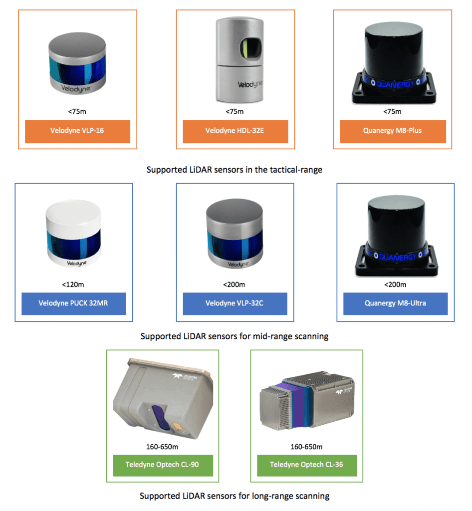
Supported LiDAR sensors in the tactical-range, mid-range, and long-range scanning
Originally published by Geodetics


